History
Sedgefield's development story
From farmland and early streetcar-suburb spillover to a postwar subdivision boom along Park Road — how Sedgefield came to be.
Charlotte's postwar expansion south
For the documented version — the 1908 Marsh family farm, the Devonshire and South Park plats, and the Marsh Realty brochure that named the place — read the Sedgefield story.
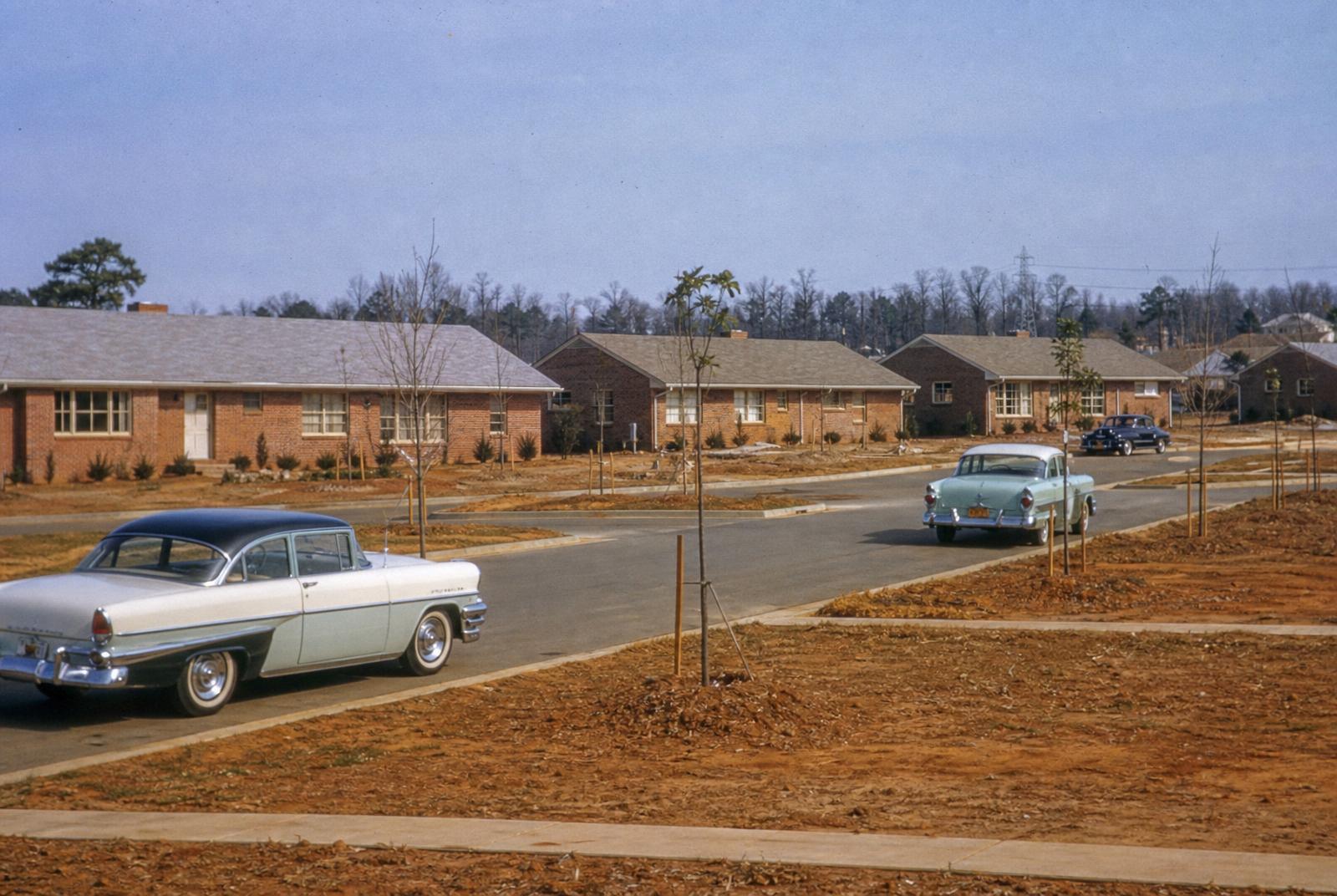
Charlotte grew rapidly in the decades following World War II, as returning veterans, new households, and an expanding banking and textile economy drove demand for housing well beyond the streetcar suburbs of Dilworth, Elizabeth, and Myers Park that had defined the city's early-20th-century growth. Developers turned to land further south along the Park Road corridor, platting new subdivisions aimed at a rising middle class who wanted a house and yard within a short drive of downtown.
Sedgefield was one of several neighborhoods built out in this wave, developed in phases roughly from the 1940s through the 1960s. Unlike the grid-patterned streets of the older streetcar suburbs, Sedgefield's streets curve and loop in the manner popularized by mid-century American subdivision design — laid out for automobiles rather than trolleys.

Annexation and city services
As Charlotte's built-up area expanded south, areas like Sedgefield were incorporated into the city through annexation, bringing municipal water, sewer, and other city services to what had been unincorporated or loosely developed county land. This pattern — private developers platting subdivisions ahead of, or alongside, city annexation — was typical of Charlotte's growth model throughout the mid-20th century. Precise annexation dates for individual parcels are a matter of public record; the Mecklenburg County Register of Deeds and city planning archives are the authoritative sources if you need documentation for a specific property.
The Park Road corridor and the shopping center era
Park Road Shopping Center, built in the mid-20th century, became a defining commercial anchor for Sedgefield and the surrounding neighborhoods, reflecting a broader national shift toward car-oriented retail centers serving new residential subdivisions. Its long operating history and gradual modernization mirror Sedgefield's own trajectory: a mid-century foundation that has been renovated and refreshed in place rather than wholesale redeveloped.
From stable postwar suburb to renovation market
For much of the late 20th century, Sedgefield remained a stable, unremarkable residential neighborhood — solid brick homes, long-tenured owners, modest turnover. That began shifting in the 2000s and accelerated through the 2010s and 2020s as rising prices in Dilworth, Myers Park, and Madison Park pushed buyers to look at adjacent, less-expensive areas with similar access to Uptown. Combined with the redevelopment of the nearby South End/LoSo corridor along the LYNX Blue Line, Sedgefield began attracting renovators and builders in greater numbers.
Today's Sedgefield reflects that layered history directly in its streetscape: original 1950s ranches, tasteful additions from the 2000s and 2010s, and full new-construction homes from the past several years, often standing on the same block. See our architecture guide for how these eras show up in the housing stock itself.
What came before the subdivisions
Before postwar development, the land that became Sedgefield was, like much of Mecklenburg County outside the city core, a mix of farmland and undeveloped acreage well beyond Charlotte's early-20th-century footprint. The streetcar suburbs — Dilworth, Elizabeth, Wilmore — were built along fixed rail lines that dictated tight, walkable grids close to Uptown. Once those streetcar lines were phased out in favor of buses and private automobiles in the 1930s and 1940s, the constraint that had shaped Charlotte's earlier growth disappeared, and development could leapfrog further out along roads like Park Road, which itself began as a more modest rural route before it became a commercial corridor.
Street patterns as a historical fingerprint
You can read a lot of this history directly off a map. Sedgefield's loops and curves, cul-de-sacs, and irregular block shapes are a direct product of mid-century subdivision planning theory, which favored curving streets to slow traffic, discourage cut-through driving, and create a sense of enclosure — a deliberate contrast to the rigid, walkable grids of Dilworth or Wilmore built a generation earlier. That difference in street pattern is one of the clearest ways to tell, at a glance, which decade a given Charlotte neighborhood was primarily built in. Our street-by-street notes page goes into more detail on how this plays out block by block.
The 1950s and 1960s building boom in context
The postwar decades were Charlotte's fastest sustained growth period until the banking boom of the 1980s and 1990s, and residential construction along the Park Road corridor was part of a citywide pattern of suburban subdivisions filling in the land between older streetcar neighborhoods and the city limits. Builders in this era worked quickly and somewhat interchangeably — many of Sedgefield's brick ranches and Cape Cods share floor plans and detailing with homes built in the same years in neighboring subdivisions, a hallmark of the production-builder approach that defined mid-century American suburbia more broadly. See architecture for how those styles are identified and dated today.
Decline, stability, and rediscovery
Unlike some postwar suburbs that saw significant disinvestment in the late 20th century, Sedgefield's proximity to Uptown and to consistently desirable neighborhoods like Myers Park helped it avoid the sharper cycles of decline seen elsewhere. It's more accurate to describe Sedgefield's mid-to-late-20th-century story as one of quiet stability — long-tenured owners, modest turnover, limited redevelopment pressure — followed by a distinct rediscovery period beginning in the 2000s as adjacent neighborhoods became increasingly expensive. That rediscovery accelerated further once the LYNX Blue Line opened and South End redeveloped from an industrial corridor into one of Charlotte's most active mixed-use districts, putting Sedgefield within easy reach of amenities it hadn't previously had on its doorstep.
Reading the neighborhood's history in public records
For anyone doing serious research — genealogists, historians, or simply a curious new owner — Mecklenburg County's Register of Deeds holds original plat maps and deed records that can date individual subdivisions and lots with far more precision than any general guide can offer. The Charlotte Mecklenburg Library's historical archives and local history room are also useful starting points for old aerial photography, city directories, and newspaper coverage of the Park Road corridor's development. We link to these and other primary sources below rather than restating unverifiable specifics here.